Sur2Circle

24toppix

This is a road trip from Big Sur, California to north of the Arctic Circle in Alaska in September and October of 2015. To read about the  events as they happened, scroll down to the bottom. (You may need to click on the “older posts” buttons.) Start at the Introduction, then read each day above that. Keep in mind that this is a “first draft,” so additional photos and edited text may be added later.  Almost 2,000 photographs were taken, and at this point we are still waiting for the film shots to be returned from the processor.

Comments are always welcome.

Also see: http://www.ebooks4ipad.com for more illustrated works.

Oct. 14th

Tomales Bay looked like a nice place for kayaking, but I didn’t stop.

I talked with Mike who was hiking in Utah.

At one point I had to crowd the road edge (no guardrail; cliff dropping to the ocean) when a tractor trailer from the other direction had to cross the yellow line to go around a sharp curve.

I planned to cross San Francisco at mid-day to avoid the morning and evening commutes.  I went across the Golden Gate Bridge at 11:57 AM which was easy because they took a photo of the front license plate so as to send me a bill, but I don’t know what would have happened if I had been using the old Tracker which didn’t have a front plate, or if Fredricka and Gary went through with their Land Rover which had a German license plate.  There was plenty of traffic in the city, but it wasn’t horrendous.

4549s

I thought that I was past the worst of urban traffic, but then there was Santa Cruz. It was bumper-to-bumper, stop-and-go traffic to Capitola. If it was that bad at mid-day, the morning commute must be a nightmare!

South of Carmel traffic was very light.

664endTRK

I got home just before 6:00 PM

I had been on the road for 8,775 miles.

Oct. 13th

I could not find NPR radio at Navarro Point, but I did find a station which featured a “Grateful Dead Hour,” but it was not being broadcast when I listened in. If you are in the area, check 95.3 FM.

The deer were still here  this morning.

I returned to the Navarro River where I saw and talked with a couple with a roof tent deployed. They had two kids and a dog, but I presume that the dog was not in the tent.

4546s

I noted that logging trucks continued to travel south on Highway One, so I assume that they were going down the road west of Ligget. A hairpin curve and a forty foot long truck coming at you can make for nerve racking driving.

I stopped at rest area where CalTrans workers were replacing a broken guard rail post. I was in the camper and approached by a youngish bicyclist who asked for a match. I gave him a book of matches, and he brazenly lit up a joint even though it was obvious that he was already stoned.   The etiquette of such situations was that you always offered to share with whomever was with you, but he was oblivious to this.  It turned out that he was Kevin from Portsmouth, New Hampshire, but even when I was a black leather jacketed, 1970s, biker in NH this was the custom even among chance strangers. What would Emily Post say about this? Kevin was going to Garberville; what was there about that town that attracted such people?

I checked in with Kary at Big Sur where there were a few drops of rain, but things were otherwise quiet.

I stopped for the evening on the side of the highway. Two fishermen stopped at about 6:00 PM to try their luck. They had the usual supplies: two spinning rods, a tackle box, a pound of squid for bait … and a twelve pack of beer! They didn’t come back until an hour after sunset. I was relieved to see that I didn’t have to mount a rescue excursion for inept sportsmen, but I had become worried that this was looking to be the case.

Oct. 12th

I hiked back out onto the dunes after breakfast to see if I could capture some interesting images in the morning light. I noticed that there were a lot of blackberry brambles at this location, but  the fruit was not yet ripe.

591sands

Next, I stopped at the mouth of the Navarro River. In the nineteenth century this was a thriving place with a sawmill, inn, etc. giving hundreds of people employment. Now it is an economically dead zone with only a lone park ranger picking up trash working … plus a maybe few gardeners for the rich people with the scattered luxury homes well above the beach.

617houss

Weather and water conditions were in premium shape, so I did some kayaking here.

4543s

There was a $25 fee to park overnight here at the beach where you could get tent space plus a picnic table.  However, I did not need such facilities, and there was free parking just three miles down the road. So, Navarro Point was where I stopped for the night.

About an hour before low tide, four oriental-looking fellows came in. They put on wetsuits and headed for the ocean. Abalone hunters?

Oct. 11th

It was very foggy this morning. I spent last evening some three miles south of the Humboldt Lagoon with the intention to return to the park for some kayaking. Alas, the weather didn’t co-operate, and I couldn’t see more than fifty feet.

543fog

Lots of redwood trees with ferns and oxalis plants at the base are in this area.

552redWD

Extreme drought conditions can be seen in the Eel River; there is a broad band of gravel with a thin ribbon of water. NPR reported that a Fort Bragg restaurant didn’t have water for dish washing, so they were using paper plates and disposable plastic forks and spoons.

555eela

Highway One is paved! The last time I was down the start of this road, it was dirt, and used by large logging trucks. It is still a road with extreme hill curves and numerous hairpin turns. Fortunately, since this is Sunday, the log trucks were not on the road. On the uphill parts it was third gear with occasionally dropping into second; downhill it was third and fourth gear. From the top of the hill to the flatland it was about twenty miles.

561hwy1

It was a relief to suddenly come out of all those tight curves to the ocean.

562ocean

Across the road from Abalone Point was new home construction going on right in the middle of the viewshed. Maybe the Coastal Commission doesn’t apply to the very wealthy?

564housa

I spent the night adjacent to a huge expanse of sand dunes at the southern edge of Ten Mile Beach.

Of course, the advantage of living on the coast is that you get uninterrupted sunsets.

572sand

590s

Oct. 10th

I stopped at the Eagle Point Walmart. I took Phoebe’s suggestion, and got a pair of light shirts to replace the wool and flannel ones that I packed for Alaska. (I took only two light shirts.)

I crossed into California at about 11:00 AM, and traveled down the Redwood Highway. There was light rain and drizzle with overcast skies when it was not actually raining. By 1:20 I was back down to the ocean! In one day I went from almost 9,000 feet at the top of Mount Scott to sea level.

515sea

I stopped at the Humboldt Lagoon and met a family with two young children. They were setting out for a canoe camping excursion. This was the three-year-old’s first camping experience, and the man confesses that he didn’t know what to expect. We discussed the requirements for camping and parking permits–but apparently they weren’t needed for a day trip. The water looked good, so I decided to return the next day.

As I went south, I encountered a herd of about three dozen elk. I was able to take several shots with the 200mm lens.

537elk

I stopped for supper and listened to Garrison Kellior’s Home Companion and the evening news. The drizzle turned to light rain by 5:30 PM. There were wild blackberries at this location and I picked about two cups worth as a treat for the breakfast cereal.

540bbery

Oct. 9th

Route 62 has virtually no night traffic, so things were very quiet. I didn’t get up for coffee until 5 AM–clear star-lit skies–and I didn’t see my first car until 6:15 AM.

I returned to Crater Lake, having noted that the light angles for photography would be much better in the morning. I went along the east rim so as to catch the early light on the western side. However, as I came over one hill, the full sun centered in my windshield, and I was totally blinded. Fortunately, there was no traffic at that early hour (7:30 AM) and I didn’t drive drive off the road. This happened on several other locations, but I was able to use my hand to block the sun sufficiently so that I could follow the center line or the edge of the road. However, this condition could be a disaster for inexperienced drivers. It is a good thing that tourists don’t get up early.

I took a variety of digital and 6X12 film shots, and I expect to be able to get a few good poster-sized images.

crtr435

I climbed Mount Scott, and again the official signage warned … “Difficulty Strenuous.”

crtr437

In reality, the trail was a wide, graded pathway to almost the top, with only the last quarter mile having rocky footing.

crtr484

The fire lookout at the top was closed and locked. There was a local NPR report that Oregon was going to close all of their fire towers and install video cameras at those locations. This may be more efficient and economical, but one of the most romantic jobs in government service is disappearing. This wild isolation may have been a factor which contributed to Jack Kerouac becoming a writer … or maybe it caused him to drink himself to death.

crtr456

In the lee of the fire tower I met a couple from Switzerland who had been traveling all summer and planned to continue until November. They had come down from Alaska and learned in Tok that “the highway at the top of the world” was closed. So, I wasn’t the only one disappointed by this fact. They had just passed through Roseburg yesterday, and couldn’t figure out why all the flags were flying at half mast. Apparently they didn’t follow the news, so I explained the tragic shooting that occurred there.

From the top of the mountain there were great views of the lake and surrounding territory.

crtr470

crtr457

Going down the trail only took an hour, because I didn’t take any breaks except to occasionally take a photograph.

crtr478

Oct. 8th

I was up early for coffee and breakfast and subsequently listened to the radio as I edited the first two posts for this blog. The local stations were still dominated by news of the recent shootings at nearby Roseburg. Between 6:05 and 6:15 four cop cars went by, all with their lights flashing and two with sirens going.

I entered Crater Lake National Park at 8:15 AM and paid $15 to the “iron ranger.” There had been a major fire in the area recently and there was still smoke and the smell of burnt wood. Even though the fire was contained, there still a few areas where things continued to smolder.

fire363

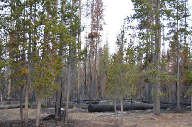
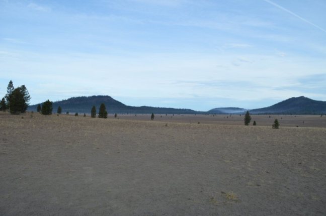
At the Pumice Desert area, distinct smoke could be seen in the distance.

crtr365

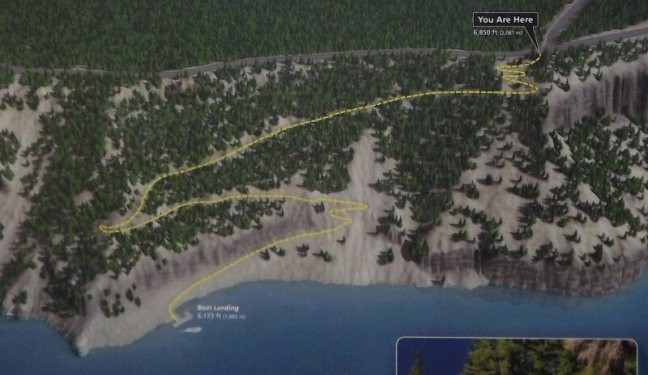
At about 9AM I took a hike along the Pacific Crest Trail. I did about two and a half hours on the trail, and I didn’t see anyone until I was within a hundred feet of returning to the truck.

CRTR492

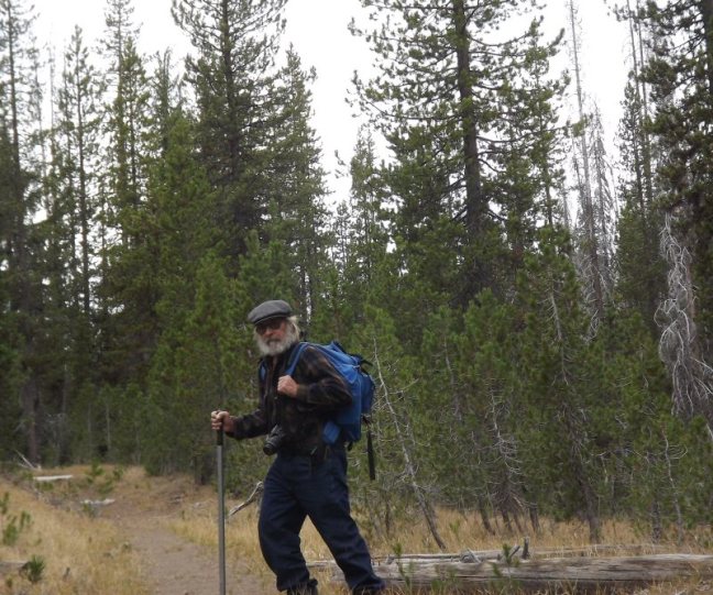
Two guys and their dog were hiking north, but they didn’t have huge Cheryl Strayed-type packs. We only spoke briefly. Mostly they wanted to assure me that their dog was friendly. The trail itself was wide, with gentle up and down slopes, and free of obstacles. Although environmentalists would be aghast, I could have driven the truck everywhere I hiked, but, of course, getting away from such things was the reason why we go on hiking trails. Once away from the road, everything was very quiet. I saw only a few small birds and a chipmunk-type critter. Although there were deer tracks crossing the trail and one old pile of bear droppings, I saw no large animals.

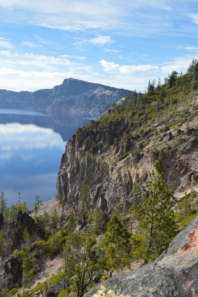
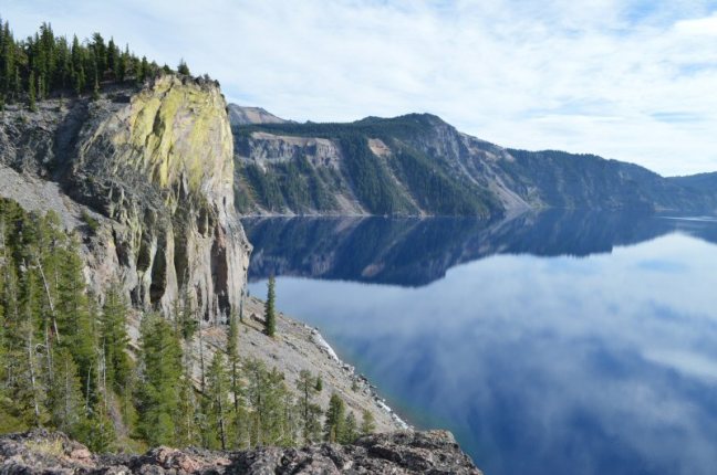
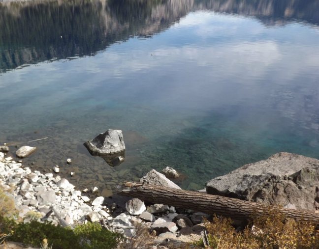
The way that the rock ledges drop almost vertically to the water is impressive. It certainly could tempt rock climbers, but is is nor clear how friable they might be.

CRTR401

crtr404

In the afternoon, I did some more hiking, this time descending down some 700 feet in elevation to the lake itself. The trail was so wide and graded that the Forestry service was able to use a Kubota tractor to bring down masonry supplies for trail repair.

crtr4503

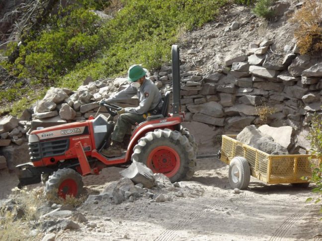
In the photo below, the Kubota was at the turn on the far left of the illustration; they were working at the next downhill turn.

crtr4515

It is reported that the lake now contains rainbow trout and kokanee salmon. I used my 12 foot flyrod and tried a variety of patterns, all to no avail. The shoreline where I fished had a jumble of rocks fallen from the ledges above, similar to many places in Big Sur, however, nothing here was covered with slippery, slimy seaweed. I did see more than a dozen rises, but they all appeared to be very small fish. The water was very clear, but I could not see much evidence of life. There were no schools of minnow-like bait fish cruising the shallows, and there was no vegetation. What those rising fish were feeding on was not obvious. On the way up, I asked the mason doing rock work along the trail about the fish, but he didn’t know about them.

crtr4501

Although the light conditions were not entirely favorable, I did take several 6X12 film shots of the lake. Maybe I can “photoshop” them into acceptable images. I left the park at 4:45 PM and stopped for the evening about five miles down the road. With four to five hours of hiking for the day–this after not having much hiking lately–I expected to have a good night’s sleep.

Oct. 7th

TRUK285

I took a bath in Rock Creek in the morning, and it felt good to be squeaky clean, but burrr!  the water was cold! Aside note: contrary to the opinions of Puritanical conservatives, cold water does not deter you from thinking about hot women.

I spent a lot of time exploring and photographing the North Umpqua River. I met two fly fishermen, Steve and Walt who had not yet caught anything, but they pointed out that it was early, and they were optimistic. They appeared to be in their sixties, and Steve had been fishing these waters since he was fourteen. For the moment, they were fishing for “summer steelhead,” but the river also had rainbow, brown, and cutthroat trout.

Seasonally, steelhead and chinook salmon come up the river. We discussed flies appropriate for such fish. They favored muddlers and also ones called a “skunk fly” and a “chappy.” We compared fly boxes, and theirs were very colorful and bright, whereas my New Hampshire/Maine flies were more somber works in grays, browns, and other muted colors.

We met again further upstream where there was a footbridge over the river. They were hoping to be able to see fish in the water from this vantage point, but they didn’t, although Steve saw something rise further downstream.

bridge97

flyfish8

Late morning I switched to waterfall photography. I hiked up to the Watson Falls which has a 293 foot drop down a sheer cliff.

falls33

This was a low water time of the year, but it is obvious that this would be a spectacular sight during the spring snow melt. At this location I saw a small squirrel, similar to the NH red one, but this one was darker and grayer, plus it sounded much differently–more bird-like in tone.

A few miles up the road I photographed the Clearwater falls–a stream with a lot more water, but a less dramatic fall. The area was covered with a lot of mosses.

I stopped traveling at about 2 PM. many places in Oregon are marred by ugly clearcuts, but this area appears to have been marked for selective cutting. Large trees were marked with orange paint. Trees in the area are mostly fir and hemlock, but there are also pine and this in the area.

clear53

mark58